Elm Street was no doubt named for the abundance of trees of all types that covered this area. The earliest survey mentioned upwards of a dozen varieties.
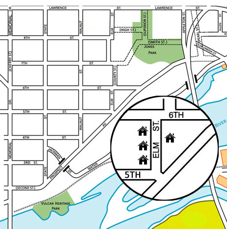
South Elm Street is arguably the crookedest street in the Old Third Ward. Almost from the time streets were platted, S. Elm wrapped around the Outagamie County Courthouse area. The portion on the eastern border of the courthouse was at one time called County Street. Just north, wrapping around the Outagamie County Justice Center, is a continuation of S. Elm, but it is not marked as such. South Elm ends at W. Lawrence St.
The portion of S. Elm St. that runs north of W. 6th St. no longer contains any homes. The builings on this street are Outagamie County and City of Appleton buildings, plus an Outagamie County surface parking lot.
When there was a municipal pool on S. Water St. just east of the old Water Treatment Plant, a set of stairs led from W. Prospect at the foot of S. Elm St. However, as late as 1925 S. Elm extended from its current terminal point at W. Prospect straight down to S. Water St., following the path where the ruins of the stairs still exist.
From Morrow and Gillett's Appleton city directory, for 1889-90:
ELM, 919 Lawrence, south to Water, second west of Appleton, numbers from 410 to 555
In 1925 a new system of numbering structures in the city of Appleton was adopted. In this directory both the new and old street numbers are given. In addition, College Ave. was designated the dividing line between north and south, and Oneida St. was the east-west divider.
From Wright's Appleton city directory 1925:
ELM S - From 401 W Lawrence A to Water, 3 w S Oneida