A small river (Fox) very much incommoded with falls, discharges itself into the bottom of this bay and is known under the name of the Riviere des Renards, or River of the Foxes, on account of its neighborhood to the Outagamies, commonly called the Renards or Foxes. All this country is extremely beautiful.
-- Charlevoix's Voyage to North America, Vol. I, 1721
The Fox is a turbulent torrent for almost its entire course through the county. There could have been hardly a mile, in the early days, where the Fox ran smoothly between its high banks.
-- The American Archeologist
The history of the Old Third Ward area of the city of Appleton is tied to the Fox River, as is all of Appleton. Before Europeans explored and then settled here, the Fox River was a conduit for native people. Some sources claim there were few or no permanent settlements along the Fox in this area since the rapids and falls made travel so treacherous. The high bluffs along the river also made access to and from land difficult. But there were numerous nomadic hunter-gatherer tribes traveling through the area, living off the land and the river. European fur trappers and traders joined the natives early on to take advantage of the abundance of beavers - to make gentlemen's hats that were in fashion at the time.
European explorers crossed he Atlantic in the hope of finding routes to the treasures of the Orient. The Spanish sailed around the horn of South America and the French were determined to find the "Northwest Passage." New France was settled at the beginning of the 17th century in what is now Canada. Jean Nicolet arrived from France and spent years perfecting his language skills before setting out along the St. Lawrence River. He had been told of a strange tribe called the Winnebago who lived across a huge lake (Michigan) and who were called people of the stinking water," "Puants" as the French called them. To Nicolet "stinking water" meant only one thing: salt water. He was certain these people came from across the ocean and could lead him to the Northwest Passage. In reality the "stinking water" referred to the algae-ridden water of Lake Winnebago and the lower Fox.
He entered the Bay des Puants (Green Bay) in 1634 and made his way up the Fox River to Lake Winnebago, passing through the Grand Chute just east of Vulcan Heritage Park. He never found the route to the other "great river" - the Mississippi.
It wasn't until 1673 that Father James Marquette, along with Louis Joliet, would set out on his journey and discover this route. His travels took him up the Fox River to Lake Winnebago, then over a portage to the "Meskousing" (Wisconsin) river, which lead to the Mississippi.
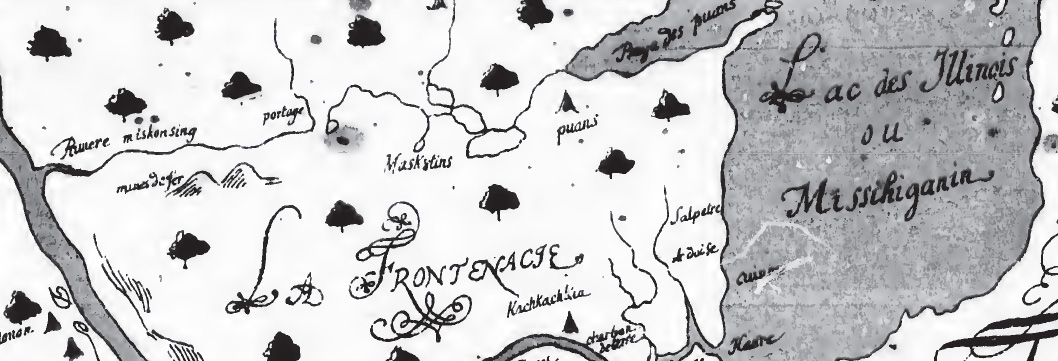
Map from Griffin Discovery of the Mississippi... The author states this appears to be a facsimile of Joliet's original map, 1673 and 1674.
The next 100 years were taken up with Indian wars, and more explorers, missionaries and trappers. By 1775 most of the Europeans has abandoned the area because of the warring tribes. This French-claimed territory passed to the British and finally, after the War of 1812, to the United States That paved the way for displacement of the natives and arrival of the settlers.
Next: The Settlers
Sources consulted:
de Tonti, Henri. Relation of the voyages, discoveries, and death, of Father James Marquette ...
Fox, George R. "Outagamie County Antiquities." The Wisconsin Archaeologist.
Griffin, Appleton Prentiss Clark. The discovery of the Mississippi, a bibliographical account [microform] : with a fac-simile of the map of Louis Joliet, 1674. New York: A.S. Barnes, 1883.
http://www.archive.org/details/cihm_29025
Risjord, Norman K. "Nicolet's Search for the South Sea." Wisconsin Magazine of History. Vol. 84, no. 3,
Ryan, Thomas Henry. History of Outagamie County..., Part 1. Chicago: Goodspeed Historical Association
Thwaites, Ruben Gold. Father Marquette. New York:D. Appleton & Company, 1908.
Charlevoix, Pierre-François-Xavier de; trans. Louise Phelps Kellogg. Journal of a Voyage to
North-America...Vol. 1. Chicago: the Caxton Club, 1923.
facs. of 1761 ed.
(http://ia600409.us.archive.org/6/items/journalofvoyaget01char/journalofvoyaget01char.pdf)
Springfield, Il.: H. W. Rokker Co., 1903. Collections of the
Illinois State Historical Library
http://www.archive.org/details/relationvoyages00librgoog
Vol. 15, No. 1 (March, 1916)
http://ia700301.us.archive.org/8/items/wisconsinarcheol15wiscrich/wisconsinarcheol15wiscrich.pdf
(Spring 2001) (http://www.wisconsinhistory.org/wmh/pdf/spring01_risjord.pdf)
Publishers, [1911?]. http://www.foxvalleymemory.org/Ryans/indextext.html
http://www.archive.org/details/fathermarquette01thwagoog