"The banks are abrupt and high, and as you turn the point the river spreads out into a bay towards the west, making a great curve to the Grand Chute above. The current on the east side, flowing in nearly a straight line, meets the flow from the curved line and causes a cross current that piles up the water in great confusion and makes the pas- sage difficult. With a smooth rock bottom and great boulders strewn about, many quite near the surface, with insufficient water above them to float the boat, it requires great care to guide the craft in safety through this turmoil. As the water is deep, often reaching to the armpits, it paralyzes half the strength of the men; their only safety is to cling to the boat and inch by inch force her through the flood.The roar of the Chute above, mingling with the noise of the fast-flowing rapids below and around, tries the strength and courage of the hardy boatmen, but they are equal to the task. With a whoop and a rush they enter the troubled water and breast the fearful tide; the victory is soon won, the haven is near."
-- John Wallace Arndts imaginary trip on the Fox River in 1830 from Arndt, John Wallace and Lyman Copeland Draper. Chapters in Fox River Valley History.... Madison, Wis.: State Historical Society, 1913.
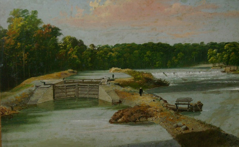 "Lower Locks at Grand Chute Wisconsin" [1857] Samuel M. Brookes and Thomas H. Stevenson. Used with the kind permission of the Green Bay-De Pere Antiquarian Society
Before a system of locks and dams was constructed, the Fox River was a series of rapids and falls. The most treacherous was the Grand Chute, which lay near the foot of what is now S. Jackman St.
In March of 1840, the Secretary of War published a report to the 26th Congress, 1st Session, titled Survey of the Neenah and Wiskonsin [sic] Rivers, Report on the "further survey and estimate of the cost of improving the navigation of the Neenah and Wiskonsin rivers, and connecting the same by a navigable canal or water communication." The "Neenah" river mentioned here later came to be known officially as the Fox River.
This area of country was an essential link in the series of waterways leading from the Atlantic Ocean to the Mississippi. If this route were to be fully exploited, there would need to be "improvements" in this portion of the Fox River. These improvements would involve building a complex system of locks, canals and dams from Green Bay to Lake Winnebago. By 1855 the waterway from Green Bay to the Mississippi was complete.
There is still a waterfall on the Fox River at Vulcan Heritage Park west of the foot of Jackman St.

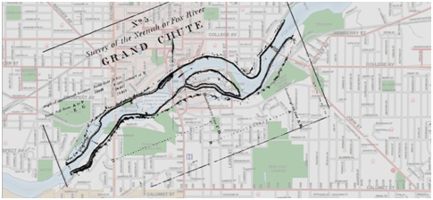
Map of the Fox River from the Survey of the Neenah and Wiskonsin [sic] Rivers, with the Grand Chute indicated with the "X" on the river under the column of numbers, and a contemporary map showing the location of the Grand Chute below the Old Third Ward.